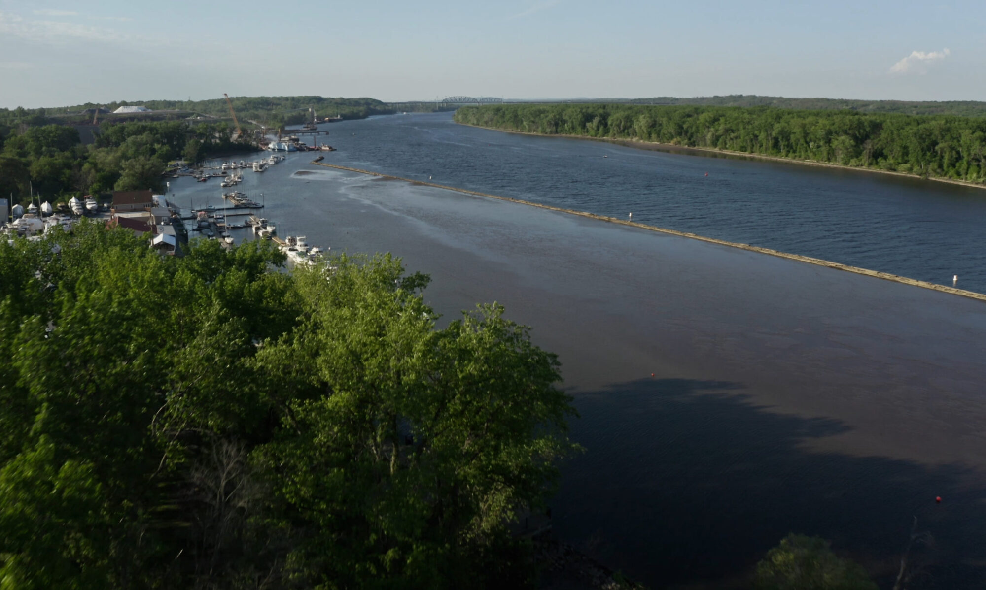
Read our Letter to the DEC Regarding the Port of Coeymans application, ID 4-0124-00012/00040 and regarding the in-water work to expand wharf area
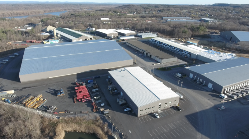
INTRODUCTION: The Port of Coeymans has been expanding in size and scope without much interference, limits, or barriers since 2006. Aggressive owner, Carver Laraway has been shown to have a voracious appetite for land and resources. Driven by money and influence, he has set the stage to turn this area into the largest waste depot in the Northeast!
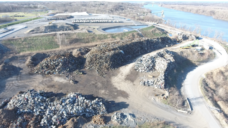
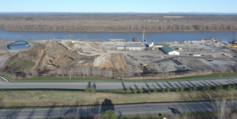
Piles of C&D waste, refuse and various metals are currently stockpiled close to the Hudson River. More are anticipated shortly. Why here? No doubt to burn at the nearby Lafarge cement kiln (and other area kilns) if our State government gives in to political pressures and issues permits without adequate review. For years, the understaffed DEC has only been able to provide marginal oversight. Town residents are unaware of the consequences that this will have on our health and safety. We at the CAC are determined not to let this happen. However, short of a majority outcry and majority vote from the community, our efforts are in vain. Please review what CAC founding chair, Barbara Heinzen submitted in March 2022 in response to the Draft Environmental Impact Statement for the P&M Offshore Wind Infrastructure Project (POWI).
Comments covered fall under 5 headings:
- Is this project needed and is it urgently needed at this time?
- What are the long-term ambitions of the Port and its associated businesses?
- Have issues important to local residents been adequately covered?
- What are the off-site impacts of the proposed work?
- Miscellaneous issues
1. IS THIS PROJECT NEEDED?
Why is this work required?
On page 9, under the heading of Purpose, Need, and Public Benefit of the project, it is noted that the Port of Coeymans was chosen as a site to develop wind power because the “existing Port [is] capable of providing the necessary fabrication and laydown areas as well as support and maintenance services associated with these types of heavy lift projects.” In light of this statement, the Port of Coeymans is already suitable for wind power without requiring additional major work.
Recommendation: Because of the substantial environmental impact of this project, the applicant needs to make the case that this work is needed at this time to support the Sunrise Wind project.
The proposal may be based on a false premise.
The Draft EIS implies that Equinor’s project, Empire Wind, will still be using the Port of Coeymans to build large concrete structures to be floated downriver to their NY Offshore Wind Power locations. (See Figures 8 and 10 on p. 61 and 63 in the DEIS for illustrations.) However, in 2021, Equinor decided to use monopole technology rather than concrete bases because monopoles have a lower cost. Equinor is not, therefore, planning to work with the Port of Coeymans at this time. Their decision was shared with me and several others during a call on October 25, 2021, with Ana Fisyak and other Equinor staff. Ana Fisyak confirmed this decision in an email to me received on Monday, February 21, 2022.
Instead of Equinor, the Port of Coeymans will be working with Sunrise Wind, as announced on October 8, 2021. It is my understanding that they will not be using the same technology originally proposed for this Port of Coeymans site plan. According to the Times Union, “The Port of Coeymans will serve as the assembly area for construction of wind turbine platforms which will support the Sunrise Wind offshore project off the east end of Montauk Point.” (see Article published October 8, 2021) As the entire Port of Coeymans application is based on pouring and storing exceptionally large concrete foundations before floating them down the Hudson River, the draft EIS may be based on a false premise.
Recommendation: The applicant needs to clarify what type of wind power assembly will be taking place at the Port and submit a signed statement from the wind power company describing the activities they expect to do at the Port. The wind power company should also state whether their contract can only be completed with the proposed alterations to the existing Port of Coeymans.
2. LONG-TERM AMBITIONS OF PORT & ASSOCIATED BUSINESSES – WASTE OR WIND POWER?
Long term growth of waste management in Coeymans – background & future
In addition to their large, but relatively rare assembly projects, the Port of Coeymans has always handled a high volume of C&D waste as well as scrap metal, old tires, and construction or road maintenance materials, including salt. In the process, most of the Port’s waterfront has been used for the management of waste and material for road works. This side of the Port’s business can be expected to grow after the Town of Coeymans revised key local laws in 2020 and 2021 following the 2019 election of George McHugh (former counsel to the Port of Coeymans) as Coeymans Town Supervisor. These changes are clearly aimed at building a major waste management and incineration business on the Hudson River in Coeymans.
• The Coeymans Clean Air Law, originally passed in 2019, set tougher clean air standards than the DEC or the EPA. This law was revised in 2020 to make it more likely that solid waste can be burned at the LafargeHolcim Cement plant or elsewhere in Coeymans.
• Revisions to the Coeymans Solid Waste Law in 2020 removed an earlier prohibition on the importation of solid waste and created the basis for building a large (35 acre) transfer station on the WM Biers property on Route 144, opposite the Port of Coeymans.
• Revisions to the Coeymans Comprehensive Plan in 2021 included the ambition to expand industry along the riverfront and Route 144 “wherever it is currently allowed” on land rezoned from agricultural and residential use by an earlier Town Board supported by the Port of Coeymans.
Despite these expanded legal foundations for increasing industrial-scale waste management along route 144 and the Hudson River, the DEIS states on page 111 under section 8.0 Growth Inducing Impacts:
"Despite reaching full build-out, it is not anticipated that CIP or POC will expand to any nearby properties. POC is bound by the land of LaFargeHolcim to the north, Route 144 to the west, the Hudson River to the east, and the Ravena-Coeymans Yacht Club to the south. None of these adjoining properties are willing or capable of providing additional land for further expansion of the Port. The situation is similar for CIP, which is neighboring LaFargeHolcim to the north and the lands of Biers to the east."
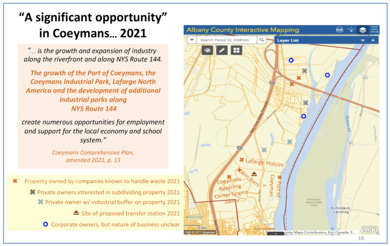
The above statement is disingenuous! Over the past 10 years, riverfront property, property along I-87, and property along Route 144, near the Port of Coeymans, have been bought by Carver Laraway or one of his companies. Carver Laraway has also been working closely with LafargeHolcim and WM Biers in order to use their property for his operations. He also has the agreement of Ten Eyck Powell III (Tripp Powell) to use his property on the Hudson River to take borrowed material from the Port’s proposed re-grading.
(As of early May 2022, the Powell family sold 50+ acres to Mr. Laraway for roughly $1.2 million)
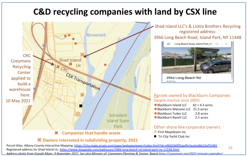
Mr. Laraway has also tried to buy the Ravena-Coeymans Yacht Club and there are rumors he wants to buy the historic Coeymans House on the north bank of the Coeymans Creek opposite the Coeymans Marina which he now owns. In addition, his companies have bought a number of residential properties in the Hamlet of Coeymans, with homeowners around the Coeymans Marina being asked or forced to sell to Carver Laraway so he can expand the Marina business in a residential area. There have also been land purchases by a Long Island waste management company, Liotta Brothers Recycling, known to work with Carver Laraway.
These purchases are shown in Figures 1 and 2, based on the tax parcel maps updated in March 2021. They show a pattern of purchases that could position future waste management businesses along I-87, the CSX line, and the Hudson River. This pattern implies that handling waste is the major growth business in Coeymans, supported by local laws revised to allow for such growth.
Site Plan for the Port of Coeymans: designed for waste or wind power?
Given the clear plans to expand the waste management business in Coeymans, it is reasonable to ask: are the proposed changes to the Port designed to facilitate waste management or wind power? If wind power is expected to occupy the redesigned Port area, where will the growing waste management business go? The current site plan shows the recycling business occupying only a quarter of the Port, possibly where a barge repair building has just been constructed. The argument that the waste management business will move to the Coeymans Industrial Park is not credible if the Park has reached ‘full build-out”.
It is reasonable to ask: is there enough room for both types of businesses – wind power development as well as the current and future waste management business? If not, where will the current and future waste business go?
Recommendation: The EIS needs to include a clear and credible statement of where and how the current, and increasing, waste management business organized by the Coeymans Recycling Center and Carver Laraway will be conducted as wind power activity increases at the Port.
Recommendation: Given the growth of the Port and its allied business in the past twenty years, the EIS needs to include a clear and credible statement of the business goals and ambitions for the next twenty years, at least up to 2035-40.
Recommendation: If this site plan is actually designed to serve both wind and waste, then the EIS needs to reflect the impact of both businesses. It should include at the very least an estimate of the increased waste handling traffic by road, rail, and river, including ship and barge traffic, that can be expected as the Port’s waste and road building materials businesses take advantage of the proposed modifications to the Port.
3. HAVE ISSUES IMPORTANT FOR LOCAL RESIDENTS BEEN ADEQUATELY COVERED?
Since the Port first opened for business in 2006, local residents have been complaining about noise and traffic. Residents have also fought the use of waste, including old tires, as fuel in the LafargeHolcim cement plant on the grounds that the resulting air pollution would be hazardous to human health. The expansion of the Port has also increased demands on the water resources of the Village of Ravena. The DEIS dismisses these impacts as insignificant, but these claims are not wholly credible, as listed below.
Noise
From the first year it opened, neighbors have repeatedly complained about noise from the Port of Coeymans. The volume of noise varies depending on the loads being handled, the wind direction, the local topography, and the time of day. The Noise study (p. 1169ff) monitored noise from the Port on July 30/31st, 2020, and August 2/3, 2021 when wind speeds were less than 11 miles an hour and scrap metal activities were taking place during the day. Noise monitors were placed (p. 1194 ff), around the immediate perimeter of the Port, at four locations on Schodack Island, and at the Coeymans House (see pages 1192-1196, DEIS).
No noise monitors were in residential neighborhoods in the Hamlet of Coeymans historic district, including along routes 143 (Church St, Coeymans) or route 144 (Main St, Coeymans) leading to New Baltimore. Nor were there any monitors in residential areas close to the Marina and close to the public landing by the Coeymans gazebo, or on Uthi Boulevard, a street running north of Route 143 that faces the Port.
The absence of noise monitors in residential neighborhoods makes the noise study seriously misleading, given the many complaints from these areas. More distantly, I (Barbara Heinzen) live on Route 144, about 2 river miles downstream from the Port at the mouth of the Hannacroix Creek. When the wind is in the north, I can hear the humming of machinery and the banging of scrap metal is loaded into a ship’s hull at the Port of Coeymans. If I can hear that noise, my neighbors who are closer to the Port are even more likely to be disturbed.
Recommendation: Additional noise monitoring is needed in the Hamlet of Coeymans, along Route 143, (Church St) and route 144 (Main St) and other residential areas of the Hamlet of Coeymans, especially on higher ground. Monitoring must be done when there is noise from the Port comparable to noise from the proposed POWI activity, especially the noise expected from the concrete batch plants.
Traffic
In addition to any noise from the Port itself, a major source of noise currently comes from the heavy industrial truck traffic along routes 143 and 144 in Coeymans and New Baltimore and on other residential streets, possibly carrying waste materials for dumping in nearby landfills or quarries. Like the noise, the traffic can vary in volume depending on the material unloaded at the Port but is especially heavy along Route 143 (Church St, Coeymans; Main St, Ravena). A short video with Joy Iafallo is the best illustration of the traffic experienced along with Main St Ravena, which begins on Church St in Coeymans. This YouTube video is courtesy of a local production company providing services in kind to bring attention to the issue.
While the video with Joy Iafallo was shot in a more commercial area, a serious impact is also being felt in the residential areas close to the Hudson River, where old houses were originally built close to the road. The trailer for another video includes several shots along Church St where a homeowner counted 420 enormous trucks in a single day. See the YouTube Trailer.
In addition to traffic along Route 143 through Coeymans and Ravena, heavy industrial vehicles also use Route 144, through Coeymans Main St and the Hamlet of New Baltimore. On both routes, the older 19th-century houses were built close to the road, often with little more than a sidewalk between the traffic and the houses. Local residents report that their houses have suffered damage from the truck vibrations. There are also often children playing close to the road in Coeymans while New Baltimore has a daycare center at an especially hazardous right-angle bend on Rte. 144. Large industrial vehicles struggle to navigate this bend, often damaging local walls.
Despite the experience of local residents and businesses and the video evidence from the Clean Air Coalition of Greater Ravena-Coeymans, the traffic study done for the wind power project concluded “The proposed project is expected to have a minor impact on traffic operations in the study area.” The study has severely underestimated the volume of traffic seen already and did not consider the impact of the traffic on local residents.
The traffic study was inadequate in several ways. First, the traffic study was largely limited to Route 144 from the Selkirk exit to the Port with a closer focus on the traffic in the immediate vicinity of the Port of Coeymans and Coeymans Industrial Park Road. Additional sampling was done at the junction of routes 143 and 144, but the traffic on Route 143 was not seriously considered, as reflected on page 51 of the DEIS: “Based on a review of the existing travel patterns, surrounding roadway network, and population centers in the area it is estimated that 55% of the site trips will travel to and from the north on Route 144, 35% will travel to and from the south on Route 144, and 10% will travel between the CIP and POC.” Second, the traffic monitoring was done in January 2021, when COVID restrictions were in place and it may have taken place when there was little activity at the Port.
Third, the traffic was only sampled for an hour in the morning and an hour in the afternoon and may have been sampled on a day when there was minimal unloading at the Port. This may be the most important limitation, as the Port’s heavy trucks are moving throughout the day, especially when a large cargo has arrived.
Fourth: the traffic study looked at the impact of traffic expected once the project was completed. It does not consider the additional traffic likely to be produced during the building work, especially the removal of 7 million cubic yards of borrowed material to enlarge the laydown area of the Port.
Taken altogether, the figures given in the traffic study are a serious under-estimate of what local residents are actually experiencing and could experience, especially the movement of heavy industrial vehicles in residential and business areas of Route 143 in Coeymans and Ravena, as well as on route 144 in Coeymans and New Baltimore.
Recommendation: Traffic monitoring on route 143, from the Port to route 9W, needs to be done for a full day, not just sample hours, with monitors that can also record the noise of the heavy trucks which is especially loud on the Church St (Route 143) hill to route 144. Traffic monitoring on route 144 through Coeymans and New Baltimore also needs to be done. Special care should be taken to ensure that the monitoring is done on days of heavy as well as light industrial truck traffic from the Port.
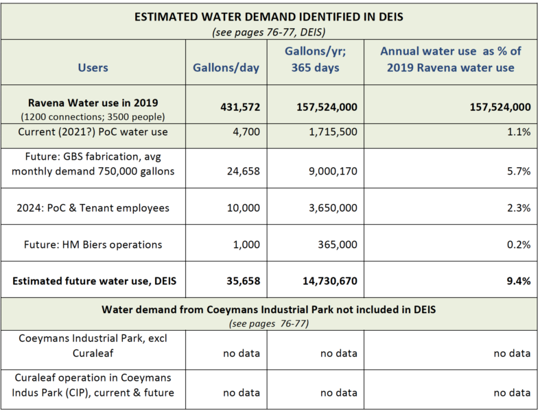
As the DEIS states (p. 76 DEIS), the Village of Ravena’s water comes from a surface reservoir fed by the Hannacroix Creek with supplemental water supplied by the Alcove Reservoir, owned by the City of Albany. Supplemental water is often needed in summer when Ravena residents are banned from watering their lawns.
While the DEIS states that there will be adequate water for the planned expansion of activities, there is nothing to back this up, apart from several letters from Ravena’s lawyer, Michael Biscone, including the letter on page 1579 of the DEIS. This letter is dated July 7, 2021, and is addressed “to whom it may concern”. It states that the Village of Ravena can “provide to Carver Companies and (sic) average of 25,000 gallons per day with a peak of 100,000 gallons per day, predicated on the fact that Carver companies shall draw during off-peak hours, and shall construct a storage site facility with a minimum capacity of 100,000 gallons. The Village of Ravena has more than ample capacity to meet these anticipated needs at this time and will have additional increase (sic) capacity in the very near future.”
Although the DEC has asked to see the inter-municipal agreement with Ravena and Coeymans that covers this increased water use (see DEIS, p. 1572), there is only this letter from Michael Biscone in the DEIS. There is no indication in the letter that Mr. Biscone is a qualified water engineer or that he is working for the Village of Ravena as their lawyer. Nor is Mr. Biscone shown holding any position in the Village of Ravena government (See Ravena website). It is not clear, therefore, what authority he has to make this claim. Nor is there any indication that the City of Albany would be happy for the Port to be using water from the Alcove Reservoir when required.
Recommendation: The EIS needs to include water demand figures from the Coeymans Industrial Park, both current and foreseen. There also needs to be clear evidence of an agreement with the Village of Ravena to draw on their water, as well as the agreement of the City of Albany if supplemental water is to come from the Alcove Reservoir. In the event that Ravena cannot supply adequate water, alternatives such as drawing from the Hudson River, need to be explored and evaluated for their impact.
4. OFF-SITE ENVIRONMENTAL IMPACTS TO INCLUDE
The Port of Coeymans footprint is described in the DEIS as consisting of the 122 acres of the former P&M Brickyard along the Hudson River. However, the ecological impact of the Port’s current operations plus POWI will go beyond the immediate boundaries of the Port’s 122 acres in at least two ways: first, the movement of any pollution coming from the Port’s redesign and operations, and second, from the depositing of borrowed material and/or waste outside the Port’s 122 acres.
Movement of pollution
The movement of pollution in this area is best illustrated by the $850,000 settlement paid by LafargeHolcim in 2021 for violating effluent limits 273 times between April 2015 and April 2021. According to the Times Union, on April 29, 2021, this settlement concerned alleged“unauthorized discharges of sulfuric acid and discharges of partially treated landfill leachate to tributaries of the Hudson River, such as Coeymans Creek and Hannacroix Creek.” (See Times Union, April 29, 2021 ) While the settlement statement did not describe exactly where the pollution originated, where it went, or how it traveled, the geography of the areas suggests that pollution might have moved down the Coeymans Creek, into the Hudson River, and from there into the mouth of the Hannacroix Creek. Or, if the primary pollution had entered the Hannacroix Creek first, incoming tides could have moved the pollution upstream from the Hannacroix, through the Hudson River, and into the Coeymans Creek. This could affect two of the endangered/threatened species named in the DEIS: the American waterwort and the Tidewater Mucket mussel that use tidal wetlands as well as endangered sturgeon and other fish.
Since 2011, I have been managing roughly 20 acres of land at the mouth of the Hannacroix Creek, an area of marsh, tidal mudflats, and swamp forest. During this time, by removing invasives and replanting with native species, the butterfly population had begun recovering but fell in 2020/2021. In 2021, no tree swallows nested on this property for the first time, due to a shortage of insects and the evening moth population was very different from previous years. There also seems to have been a decline in the amphibian population in 2021. After several years of finding wood turtles along the south bank of the Hannacroix Creek, none were seen in 2021 when I was taking and sharing daily photographs of wildlife found here. The dry weather from 2019 to 2021 may explain much of this decline, but I worry that industrial pollution was a contributing factor. I also know that the Port has allowed salt to enter the Hudson River, either along the Coeymans Creek or while unloading/loading at the Port.
Recommendation: The DEIS, on p 42, states that bottom sampling for pollutants at the Port was done in 2014. This needs to be updated and needs to include PCBs and salt. In an ideal world, sampling of areas like the bay at the mouth of the Hannacroix Creek where tides and currents may have deposited pollution from the Port should also be done.
Movement of borrowed materials
The DEIS anticipates that a total of 7 million cubic yards of material will be removed from the Port of Coeymans in order to create the space for concrete batch plants and other sites for the development of wind power. After being tested for pollutants, this material is expected to be deposited on nearby land, mostly greenfield sites between the Hudson River and Rte. 9W (See pages 26 and 27, DEIS). However, the DEIS does not assess the environmental impact of these deposits.
Attention to the impact of borrowed material on the receiving sites is needed. Among the species to be considered are the two threatened and endangered bats, named in the DEIS on p.40: the Northern Long-eared Bat Myotis septentrionalis, and the Indiana Bat, Myotis sodalist. The DEIS notes that there are no trees, caves, or hibernation sites at the Port, so there is no impact on bats from the work proposed. However, the borrowed material from lowering the grade of the Port is expected to go into areas with considerable tree cover and considerable insect life to support the bats (see the map of borrowed material locations, p. 27, DEIS). The final EIS needs to identify the specific areas where borrowed material will be deposited and identify the environmental impact of depositing such large volumes of borrowed (and possibly contaminated) material, especially the impact on bats. Special attention should also be paid to the Tripp Powell property along the Hudson River north of the Port, for the impact on the Hudson River of borrowed materials there.
Recommendation: The exact locations where borrowed materials are to be deposited need to be identified and assessed for the environmental impact on biodiversity and endangered species living in those areas.
5. MISCELLANEOUS ISSUES
Page numbers needed on the Index
In reviewing the DEIS, I have used the final draft of December 17, 2021, with all Appendices attached. Throughout the text, reference is made to documents in the Appendices which are given letter locations (“A”, “B”, etc.) rather than page numbers in the Table of Contents. As a result, it is nearly impossible to find the supporting documents in the Appendices named in the text. At the very least, the Appendices need to be given page numbers in the Table of Content.
Recommendation: Where the text cites supporting documentary evidence, a page number for that evidence must be included, in the text and in the Table of Contents.
Supporting evidence is out of date
In several instances, the evidence supporting a claim of no impact is out of date. For example: Bottom sampling for pollutants: The study cited on p.42 of DEIS was done in 2014, 7 years ago. It needs to be updated.
Vessel traffic to the Port: On page 42 of the DEIS, the last counts for vessel traffic to the Port were done in 2014 and 2016. These counts also need to be updated.
Hudson River barge traffic: The estimate for Hudson River Barge traffic, cited on p. 42 of the DEIS, was done in 2012. This estimate needs to be updated.
Presence of sturgeon, Atlantic & short-nosed: The supporting evidence for the presence of sturgeon comes on p. 888 of a study of the sturgeon population done in 2015 and 2016. These population numbers need to be updated as that can affect likely impact.
NY State Parks approval: the DEIS on p. 73 refers to a letter of approval from the New York State Parks dated 2018. However, on page 1470, a letter dated February 21, 2020, notes that this 2018 letter was rescinded. There is also a letter dated January 31, 2019, from John Bonafide, of NY State Parks, to John Cannon of the Army Corps of Engineers laying out a number of issues of concern to the Parks Department.
Recommendation: All supporting evidence must be brought up to date, within the past two years. The approval by the New York State Department of Parks Recreation and Historic Preservation must be recent and must address the issues raised after 2018.
Removal of Tappan Zee Bridge Trestles – environmental impact
After the Tappan Zee Bridge project ended, the Port acquired ownership of the Trestles and argued that it would be more environmentally disturbing to remove the trestles than to leave them in. Now the Port wants to remove them. What is the argument being made now that it is environmentally beneficial to remove the trestles?
Recommendation: The EIS must show why it is now environmentally advisable to remove the trestles rather than leave them in place.
Temporary barges on West Bank
While individual barges move in and out of this west bank location, the presence of barges is constant. The resulting shading of the River bottom reduces the habitat in this area.
Recommendation: The EIS must provide evidence that moving barges in and out of this ‘temporary’ berth on the West Bank do not affect the underwater habitat.
Cumulative impact
On pages 112-121, the Draft EIS addresses the cumulative impact of past and future industrial development at the Port of Coeymans and Coeymans Industrial Park. The overall conclusion is that the impact is low and likely to remain low. However, since the P&M Brickyard was sold, the industrial area along Route 144 and the Hudson River has at least quadrupled from the 122 acres of the Port to 500-600 acres on both sides of Route 144. Tree cover has been removed, drainage patterns have been disturbed and noise and traffic have increased. The draft EIS claims that because much of the area has been rezoned for industrial purposes there is no significant cumulative impact. However, these impacts were not there before the Port took over the P&M Brickyard and began expanding operations. Changing the zoning map does not eliminate the impact, it just gives it a legal veneer.
The Land Use map of this area is included in the 2019 Coeymans Natural Resource Inventory (See map 26A), shows about a third of the Coeymans shoreline on the Hudson River is a large gray industrial area with another large patch of blue designated commercial use along the Coeymans Creek. Both areas were young woodland and regrowth ten-fifteen years ago.
Images from Ortho NY and Google maps show how that industrial development has affected the landscape.
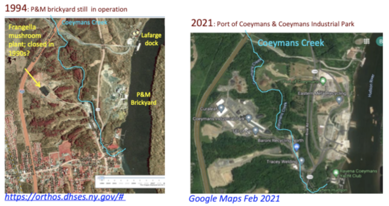
Given these images, and the experience of people living in the Hamlet of Coeymans as noted above, it is not enough to state that there has been no cumulative negative impact. Apart from a lower quality of life for local residents, there has been, at the very least, a loss of habitat, especially in the Coeymans Creek watershed, a loss of ecosystem services, such as carbon sequestration and watershed purification, as well as increased air and water pollution, including dust from salt and combustion wastes such as slag and fly ash (See November 2021 reports of salt dust in Ravena, later identified as coming from the Coeymans Industrial Park).
It is also misleading to state that there has been great benefit from this industrial development to the local community. In fact, 3/4th of the new jobs have been taken by people from outside of Coeymans, while the population of Coeymans itself has actually declined between 2000 and 2018 as this industrial growth was taking place. (See p. 20 and p. 8 in Town of Coeymans Comprehensive Plan Update Preparation Report, March 2020) If this development is so beneficial, why are people leaving?
Recommendation: The EIS must make a detailed statement of the cumulative impact of the industrial development along Route 144 and the Hudson River on local residents, especially in the Hamlet of Coeymans and Ravena. Ideally, a survey of residents in the Hamlet of Coeymans and Ravena where the impact of industrial traffic, noise, and pollution is most noticeable, should be conducted.
LETTER TO ARMY CORP
May 5, 2022
Dear Brad Sherwood:
Background
I am a resident who has lived south of the Port of Coeymans along the Hudson River since 2011. I own about 20 acres of land at the mouth of the Hannacroix Creek and have been testing ways to increase the environmental health and biodiversity of this riparian site. Soon after moving here, I began working with neighbors to protect undeveloped land around the Port of Coeymans. In December 2017, neighbors and I learned that the LafargeHolcim Cement Plant in Ravena was planning to use about a third of Connecticut’s municipal waste as fuel and also wanted to burn old tires. That led to the formation of the Clean Air Coalition of Greater Ravena-Coeymans which helped pass Town and County laws to limit the burning of waste in cement plants and other sites. Both laws were opposed by LafargeHolcim and Carver Laraway. Both laws have since been gutted or evaded under a town board led by George McHugh, former Counsel to the Port of Coeymans.1 My comments are based on what I have seen during this time.
Proposed activities at the Port of Coeymans
P&M Brick’s application is for a permit to dredge a portion of the Coeymans waterfront to a depth of 34ft and install a new 400ft wharf in addition to the existing wharf of 660ft.2 This would give the Port a total of 1040 feet of wharf frontage, able to accommodate 2 ships simultaneously instead of just one. The application also calls for a permit for a spud barge (which has been illegally parked at the SE corner of the Port for years) and the removal of finger trestles installed ‘temporarily’ during the Tappan Zee Bridge project but given permanent status when the project ended. These proposed activities are portrayed as minor, self-contained, temporary, and limited, resulting in a low impact on local society, ecosystems, and endangered species.
I respectfully submit this is not the case and that the Army Corps needs to consider not just the immediate footprint of these activities, but the consequences that will follow from them.
1 George McHugh and candidates with close ties to the Port of Coeymans were first elected in November 2019. See the Times Union of May 8, 2019, “Is Coeymans Candidate Too Close to Port Owner?”
2 For details of Port of Coeymans site in 2018 see Table 1, 2018 Ports Assessment: Port of Coeymans Pre-front End Engineering Design Report: Final Report, NYSERDA Report Number 19-04, February 2019.
Army Corps’ own rules on impacts must be considered
According to the Army Corps Public Notice, dated 14 April 2022, “all factors” need to be considered including the “cumulative (emphasis added) effects [on]… conservation, economics aesthetic, general environmental concerns, wetlands, historic properties, fish and wildlife values, flood hazards, floodplain values, land use, navigation, shoreline erosion and accretion …” among others. By defining the area of impact as narrowly as it has, the Corps is not meeting the requirements of its own rules.
Impact of current Port of Coeymans activities
Since 2006, the expanding businesses of the Port of Coeymans and the Coeymans Industrial Park have done some sub-assembly, but largely handled road building materials, road salt, construction and demolition debris, and recycled materials including electrical transformers, among other waste products. Most of what has been seen by local residents has been a waste processing and road materials business, not an assembly business. These businesses have had a serious and cumulative impact on local homes, society, and local ecosystems, including more hazardous river traffic, increased road traffic, increased noise, and increased water pollution. These impacts have not been limited to the area of the Port or its waterfront. The Clean Air Coalition of Greater Ravena-Coeymans has documented hundreds of heavy industrial vehicles moving every day along NY Routes 143 and 144, passing through residential areas of Ravena and the riverside Hamlets of Coeymans and New Baltimore. See videos.
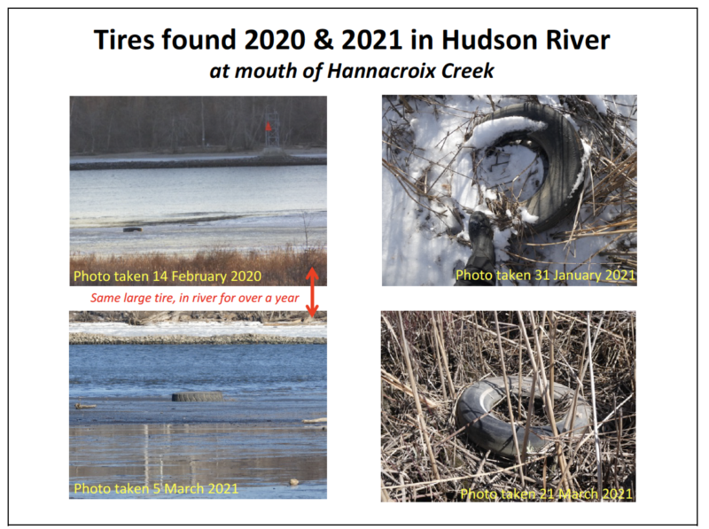
Last year alone, we witnessed salt being dropped into the Hudson River and local residents faced heavy salt dust on their vehicles on December 3rd. Since the Port began collecting old tires from around New York State, I have repeatedly found tires in the tidal mudflats and reeds of my property at the mouth of the Hannacroix Creek downstream of the Port. These are just the visible signs of a careless operator who does not respect the unique ecology of our freshwater tidal habitats, let alone the health and safety of local residents.
3 See “DEC: Dust coating Ravena was salt”, Times Union, December 14, 2021
The impact of Carver Laraway’s businesses on land use has been huge and is continuing to grow. More and more acres of land along the Coeymans Creek and the Hudson River waterfront are being added to his business holdings and those of his partners. Most recently, he bought 54 acres of Hudson River shoreline at 47 Bronk Road for less than market value, a beautiful parcel with a historic farmhouse and farmland4. This land is directly opposite Schodack Island State Park in an area previously designated as a scenic Hudson River view. The land is expected to be used as a dumping ground for fill taken from the proposed Port of Coeymans expansion project. Since 2006, roughly 6-700 acres in the immediate Hudson River watershed in Coeymans, most of which were previously zoned for residential and agricultural use, have now or soon will be industrialized. Most of this industrial development uses the Port of Coeymans.
“Dual-Use Expansion” – What business will benefit from the proposed activities?
While the applicant would like the Corps and New York DEC to conclude that this expansion will be devoted to large, heavy offshore wind (OSW), the current application notes that the stated purpose of the project is “to better facilitate current and future operations (emphasis added) at the Port of Coeymans.” Given its history, current and future activities are more likely to be dominated by waste management and other polluting operations, rather than wind power. The impact of expanding ALL the Port’s businesses must be identified and assessed before any Army Corps permit to dredge and build is granted. According to its own terms of reference, the Corps is obliged to examine more than the immediate footprint of the proposed activities. It must also look at the cumulative impact of the proposal. This must include an evaluation of the consequences of enlarging the Port’s wharf to facilitate a doubling of all its operations, including waste management and other business that have nothing to do with wind power. What will be the TOTAL impact of an enlarged wharf and Port on river traffic, road traffic, pollution of air, waters, and soils, etc., as well as on the well-being of local residents? Those of us who live near the Port of Coeymans know that this is a “Dual Use Expansion”. While we are all happy to support wind power development, we have seen that the Port’s major expansion over the past ten years has been in waste management. This has been facilitated by a Coeymans Town Board dominated by supporters of Carver Laraway since January 2020. During that time, they have altered all the Town’s institutions and environmental protection laws to enable the establishment of a major waste processing business on the Hudson River waterfront. Such a business would bring immense harm to local people, the Hudson River, and the surrounding environment.
Is this scale of change needed?
In 2018, NYSERDA looked at the Port of Coeymans’ suitability for wind power projects5. Table 1 of that report described the site characteristics of the Port of Coeymans. Table 2 summarised the estimated cost of changes that would be required to make the Port more suitable for wind power. The document as a whole describes a much smaller expansion of the Port of Coeymans than has been proposed in its current submissions to the NY Department of Environmental Conservation and Army Corps. By 2018, the Port had supported the building of the Willis Avenue Bridge, the Tappan Zee Bridge, and a major project with GE. The Port completed these assemblies with the resources it had and was therefore designated as a New York State wind power port requiring relatively modest changes.
4 This is the property’s listing, which may not be up for much longer.
Rare global habitat with a long human history
I would like to remind the Corps that this stretch of the Hudson River is ecologically rare – a freshwater tidal habitat that only exists in a few parts of the world. The Hamlet of Coeymans is a historic Hudson River town founded by the Dutch in the 17th century on an area that had been the homeland of the Mohicans for millennia before that. These are lands and waters that merit our protection, not further abuses.
Thank you very much for your attention. I am attaching my comments to DEC on the larger application to rebuild the Port. It documents better than this short letter can, why I think any further expansion of the Port of Coeymans will be damaging and unwise. Please consider those comments as part of my response to this application, NAN-2019-0113-USH. With good wishes and many thanks for your consideration,
Barbara Heinzen
LETTER TO THE DEC
6/10/22
re: Port of Coeymans application, ID 4-0124-00012/00040
re: in-water work to expand wharf area
Dear Karen Gaidasz,
I have read through the materials submitted by the Port of Coeymans concerning the proposed expansion of the Port’s docking area and the in-river work that would require. I do not find their submission to be credible and urge you and the DEC to reject this application. If you decide the work needs to proceed, the only viable, high-priority mitigation project is to make a substantial financial commitment to restoring the channels between the Hudson River and Schodack Creek, Option 3.5, described on page 49 of Part 182 Permit NOIA Response Package.
Assumptions in the Proposal
1. Assumption: Future river traffic will be unchanged
On page 34, the Port’s submission claims “The POC currently sees 2-4 vessel round trips per week to the trestles (HDR 2019). The proposed wharf is also expected to generate 2-4 round trips per week.” This, they argue, means that “vessel traffic is not changing.” This is not very credible as two wharfs will be able to handle more traffic with a greater variety of vessels, including barges than the trestles currently handle. If the same volume of traffic is expected, then why is a second wharf needed? The proposal also calls for two spud barges in the SW corner. This implies there will be an increased volume of traffic from barges in this relatively narrow stretch of the Hudson River which is a significant and rare coastal ecosystem that experiences high volumes of river traffic already. Incidental strikes of important fish species are inevitable.
Before approving this permit, we need to see accurate numbers of the current traffic at the
Port, both barge movements and large ships. The DEC also needs to get an estimate of the number of ships and barges that are likely to be using the Port in the future to serve an expanded waste processing business as currently allowed under Coeymans’ revised laws.
Recommendation: Current estimates of future river traffic are not credible and the permit should be rejected.
2. Assumption: habitat loss will be insignificant
On page 21, the Port claims that there will be only a minimal loss of sturgeon habitat: “…the
reduction in space available for migratory passage and opportunistic foraging for sturgeon will be extremely small (<1%) and any effects to Atlantic and Shortnose sturgeon are extremely unlikely.” This is a meaningless number – 1% of what? Is it less than 1% of the entire Hudson River? Or 1% of the Hannacroix-Coeymans Creek Complex? What percentage of essential sturgeon habitat in this area is being disturbed? That is the important number.
On page 22, the Port makes a different claim: “Overall, there are approximately 2.6 acres of
unavoidable new impacts to the previously un-dredged area.” This number differs from the
estimate provided in the DEC’s call for comments where it is stated: “The POWI project will result in the permanent loss of 0.87 acres of essential sturgeon habitat … [and] temporary disturbance of 4.42 acres of essential sturgeon habitat through the dredging of previously unimpacted river bottom …” These numbers means that a total of 5.29 acres will be disturbed on a permanent or temporary basis.
The DEC’s numbers raise a different question: what is the meaning and impact of a temporary disturbance? How long does ‘temporary’ last? An old saying reminds us to “beware of the permanence of temporary solutions”. Does temporary only refer to the time the dredging takes place? If so, what is the permanent impact of repeated dredging, every five years, on sturgeon habitat and populations as well as on other species living in the river?
3. Assumption: Ingalls & Associates is qualified to judge ecological impacts
In talking about the impact on sturgeon and their habitats in this area, the Port’s submission relies on a report from Ingalls & Associates, an engineering firm and long-standing contractor to the Port of Coeymans. Their report references material is out of date, irrelevant to this area of the Hudson River, and designed for a general audience. There is no independent assessment from experts on the two species of sturgeon known to use this area. Without that degree of reassurance, the Port’s submission is not a reliable guide to the impact of the proposed in-water work on local populations of Atlantic and short-nosed sturgeon. Nor does the report make any mention of the impact on other species dependent on the Hudson River.
Recommendation: The Port of Coeymans needs to provide an impact assessment from
recognized experts in the restoration of the sturgeon population in the Hudson River, with specific reference to this stretch of the Hudson River and its use by sturgeon. An expert assessment of the impact on the whole ecology of this stretch of the River is also needed.
4. Assumption: Future hydrophone monitoring can inform today’s decision
The Port’s submission relies on the future use of hydrophone monitoring of sturgeon to assess the impact of the in-water work AFTER the work has been done. This is logically useless. We need to get the best information possible on the likely and possible impacts BEFORE any permit is granted. The Port needs to provide the DEC and the public with the data that has been collected by the hydrophone monitoring done in recent years. Without that data, no reasonable decision on possible future impacts can be made. In addition to the hydrophone data that exists, the Port needs to provide the DEC and the public with any data on incidental sturgeon strikes that have taken place in this stretch of the Hudson River as the Port has expanded.
Recommendation: The Port of Coeymans needs to use and present existing hydrophones and incidental strike data to make the case that the impacts of the work will not damage the recovery of sturgeon populations in the Hudson River.
Mitigation Options
My preference is to deny a permit to expand the Port in this way. However, if the expansion
proceeds, then substantial mitigation is required. There are six projects being offered as
mitigation for the damage likely to follow from the in-water work. The current stabilization on the south side of the Coeymans Creek (Section 4.0) was largely designed to benefit the
Coeymans Marina, owned by Carver Laraway, has already been approved. It is hard to see how this compensates for the proposed damage to habitat at the Port of Coeymans and cannot be counted as mitigation of that damage. Of the other five proposed projects described in the Permit NOIA Response Package, only one can compensate for the damage that is being proposed: restoration of the channels between the Hudson River and Schodack Creek.
Option 3.1 “East” Bank Restoration
This proposal is misnamed as “East Bank” Restoration, as the photograph shows work at the mouth of the Binnenkill, on the West Bank of the Hudson River south of the railway and I-90 bridges over the Hudson River. As it happens, Carver Laraway and his business associates have bought and started to develop land along the railway for use in managing waste, so this proposal appears to be self-serving.
This option will not substantially benefit the Hudson River and could potentially harm it
further. It must be rejected.
Option 3.2 Ice House Restoration at Schodack Island, opposite Hannacroix Creek
This proposal is described on page 46 as stabilizing the icehouse chimney and foundations in the Schodack Island floodplain, thereby protecting local history and “increasing public relations with the POC”. The chimney is opposite the Coeymans Sewer Plant, at the mouth of the Hannacroix Creek, and is only visible from the River. It is not clear how unstable these buildings are at present, nor is there any obvious benefit to foot visitors to Schodack Island or to the health of the Hudson River and its resident species. We can, however, expect that the Port of Coeymans and its owner will exploit the PR opportunities of the project while continuing to be careless with the Hudson River’s wildlife and shoreline. 1
This option will not benefit the Hudson River and must be rejected.
Option 3.3 Tidal Wetland Restoration, opposite Hannacroix Creek
This project is located on Schodack Island and is also opposite the mouth of the Hannacroix Creek. In fact, restoration took place in 2020 and it is not clear what more needs to be done as heavy machinery reshaped the area and major planting was done. Given the 2020 work, the Option 3.3 Tidal Wetland Restoration proposal is simply a cheap offer to pick up the usual river trash.
This option offers no additional benefits to the Hudson River and must be rejected.
Option 3.4 Hannacroix Creek Inlet Restoration
In 2010, I bought just under 20 acres of land at the mouth of the Hannacroix Creek and moved here in November 2011. Shortly before moving in, Tropical Storms Irene and Lee flooded the Hannacroix Creek, scouring the creek bordering my property and leaving only bare mudflats Today, eleven years later, I see more cobbles, abundant bird life, and the return of vegetation. The Creek has slowly been healing itself, as shown below.
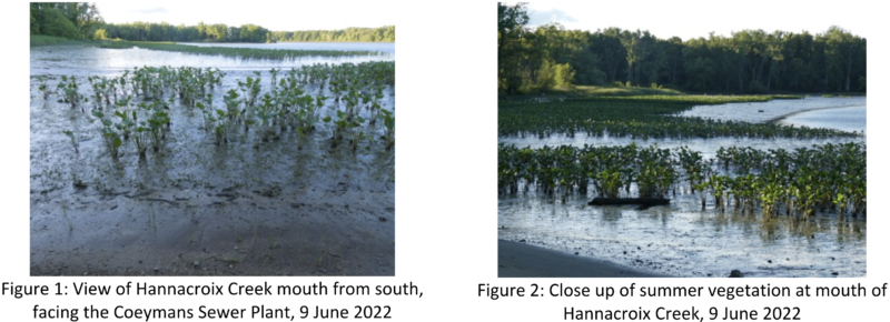
There is no need to “restore” the Hannacroix Creek Inlet which is doing the job itself.
This option must be rejected.
Option 3.5 Schodack Creek Side Channel Mitigation
According to the Port’s submission, p. 49, “The Schodack Creek Side Channel Mitigation project would involve completing the side channel restoration for Schodack Creek (Figure 5). This project is to restore habitat areas on the east side of Schodack Island and would increase fish spawning and foraging habitats and increase flood prevention. Improvements would include restoring side channels, including tidal wetlands, vegetated shallow waters, backwaters, and intertidal habitat.”
Figure 5 only outlines the east side of Schodack Creek for mitigation, but the project must
include the restoration of the historic channels that connected Schodack Creek to the Hudson River in the early 19th century. The two priority channels are the ones between Upper and Lower Schodack Island and between Lower Schodack Island and Houghtaling Island. These channels were filled in during the dredging of the ship channel, dramatically reducing the wetlands of the Upper Hudson. This is an important long-term project of the NY DEC and Parks departments.
Option 3.5 Schodack Creek Side Channel Mitigation is the only viable mitigation option
proposed and must reconnect the Hudson River and Schodack Creek. Money should go
directly to the DEC and Parks Department to support work already being planned.
Evidence of need
In previous submissions to the DEC and Army Corps of Engineers 2, I have questioned whether the Port needs a second wharf and larger landing to accommodate current wind power projects. I have argued that in fact the second wharf will be used to support a major waste processing business that requires its own environmental impact statement. My views have not changed, especially as the proposed in-water work will destroy important benthic habitats.
Conclusion
I have long argued that we need an assessment of the cumulative impact of the rapid expansion of Port of Coeymans and its affiliated businesses. Instead, we have had a series of segmented permits that have cumulatively added up to major damage to local residents and to the ecology of the Hudson River. This permit will continue that pattern, so I urge the DEC to review the wider implications of what is being requested here.
I also worry that future activities of the Port will be advertised as wind power, but be dominated by waste management. This dirty business could occupy most of the west bank of the Hudson River from the Binnenkill to Hannacroix Creek, creating an ecological disaster for these globally rare freshwater habitats. It would also increase the deleterious impact of the Port’s activities on local people, especially in the Hamlets of Coeymans and New Baltimore. I, therefore, hope and trust you will make the wisest possible decision given these possibilities.
Yours sincerely,
Barbara Heinzen
1 For example, in 2019, soon after Carver Laraway bought the Coeymans Marina, he had a cottonwood tree on the property cut down. It had been used by eagles for fishing but was destroyed to spite local residents protesting plans to build a large warehouse-style restaurant at the Marina. The new ‘restaurant’ has not yet been built despite getting planning permission.
2  See comments posted on this page - Clean Air Coalition website: https://cleanairalbanycounty.org/port-
expansion/ .
